Habblesthorpe St PeterArchaeology
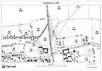
 Probable site of Probable site of
the church
|
 Map of 1886 showing Map of 1886 showing
the church site
© Crown Copyright and Database
Right 2015. Ordnance Survey
(Digimap Licence). |
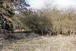
The site of Habblesthorpe church lies just under half a mile east of North Leverton church. It is marked by a roughly rectangular patch of scrub and trees, 0.25 hectares in extent, between agricultural land to the east and a drainage dyke to the west. It is accessed by a public footpath leading from Northfield Road to the south.
The church probably lay in the northern portion of the present scrub as several post-medieval grave markers are extant in the southern and eastern portions. There is a roughly level area that probably represents the site. In 1743 the church was reported as being in ruins and in 1764 there was no mention of a church in Archbishop Drummond's visitation, hence it seems probable that the building disappeared sometime between these two dates; certainly by the 1790s when Throsby was writing he states that 'the hamlet is small, it once had a chapel', indicating that there were no standing remains. No description of the building has been found in historical sources.
A survey of Habblesthorpe village for reused building stone has not been undertaken but might prove useful in locating material from the church.
Technical Summary
Timbers and roofs
|
NAVE |
CHANCEL |
TOWER |
| Main |
Not known |
Not known |
Not known |
| S.Aisle |
Not known. |
n/a |
n/a |
| N.Aisle |
Not known. |
n/a |
n/a |
| Other principal |
|
|
|
| Other timbers |
|
|
|
Bellframe
Unknown design.
Demolished.
Walls
|
NAVE |
CHANCEL |
TOWER |
| Plaster covering & date |
Not known. |
Not Known. |
Not known |
| Potential for wall paintings |
Demolished |
Demolished |
|
Excavations and potential for survival of below-ground archaeology
No known archaeological excavation has been undertaken on the site of this church.
The entire building, probably all medieval in structure, disappeared most likely between 1743 and 1764; it was certainly in ruins in 1743. The churchyard is roughly rectangular and heavily overgrown by trees and scrub, some C19th and early C20th grave markers are intact and the churchyard may once have extended further to the north. The current entrance to the site is from the west, though it is impossible to say where it lay originally.
The overall potential for the survival of below-ground archaeology on the former church site and churchyard, is considered to be HIGH-VERY HIGH comprising early medieval-C18th stratigraphy with medieval and post-medieval burials and considerable buried evidence of the former church.
|